
Summit Lake
Posted by Jim Steele on October 29th, 2012 filed in Yellowstone National ParkThe experienced hiker may begin to experience a dilemma. What do you do when you have hiked all of the big-name trails in Yellowstone National Park? Your hiking journal reads like Lewis and Clark’s diary. If the trail’s worth exploring, you’ve probably hiked it.
Summit Lake. Photographed July 4, 2012.
You’ve been to Seven Mile Hole. You’ve summited Mt. Sheridan. And you’ve seen Union Falls.
But you aren’t ready to retire your hiking shoes just yet.
You have two choices: You can start retracing your steps – go back to the Shoshone Geyser Basin, Mt. Holmes and the Bechler Canyon. Or you can start visiting some of the second-tier locations, like the Phantom Fumarole, Riddle Lake or Summit Lake.
My advice? Do both. Revisit your trips to Yellowstone’s All-Stars. But don’t be afraid to visit some of the locations that don’t make any of the Top Ten lists. They offer you a chance to get a different perspective on Yellowstone. Along the way, you’ll probably enjoy the solitude that comes from truly escaping the crowds. There is something amazing about seeing something that only a few hundred other people see each year.
Summit Lake in the southwest quadrant of Yellowstone fits this description perfectly. The hike offers a quiet trip that starts out near Old Faithful village, briefly follows the rim above the Old Faithful area, and gives you an interesting taste of the Yellowstone backcountry on a trip to a quiet lake that covers about eight miles each way. You gain about 1,300 feet.
View Larger Map
However, there are definitely caveats. Other hikes in Yellowstone offer much more dramatic scenery. In about the same distance, you could hike to Heart Lake. In much less time, you could stand atop Mt. Washburn. Don’t go to Summit Lake on your first trip to Yellowstone.
That said, this trail has plenty to offer. Excellent side trips are available on both ends. You have the chance to see some interesting thermal features. You will be following the Continental Divide Trail. And you’ll get a good view of the Old Faithful area.
Park at the Biscuit Basin parking lot, located north of Old Faithful village along the Grand Loop Road. Follow the boardwalk through Biscuit Basin and enjoy the view of the stunningly blue Sapphire Pool along the way. On the west end, a trail enters the trees. This trail leads to Summit Lake. It also can take you to Mystic Falls or the Biscuit Basin Overlook, which are both great side trips.

Sapphire Pool. Photographed April 18, 2009.
You will quickly pass a handful of signed junctions and will pass through a small meadow and cross a stream. Then you begin a tough, steady climb up to the rim above the Old Faithful area.
After the climb, you follow the rim for a while. The trail offers you a few spots to take in a view of the Old Faithful area and the foothills rising above. It isn’t the best view in the park, but it gives you a cool perspective on the Upper Geyser Basin.
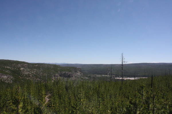
The view from the Summit Lake Trail, looking back toward Biscuit Basin, on the rim above the Upper Geyser Basin. Photographed July 4, 2012.
After you leave the rim, the trail turns in a south-southwest direction and gains elevation gradually. You follow a streambed for much of the hike. Portions of the streambed spend much of the summer dry; the closer you get to the lake, the more likely it is that the streambed will be alive. The vegetation on this hike follows a similar pattern. Closer to Old Faithful, you pass through a lot of dry, burned terrain. The forest gradually grows lusher as you near the lake. You also pass through a few small meadows. Even if for no other reason, this hike offers an interesting opportunity to watch the forest change.

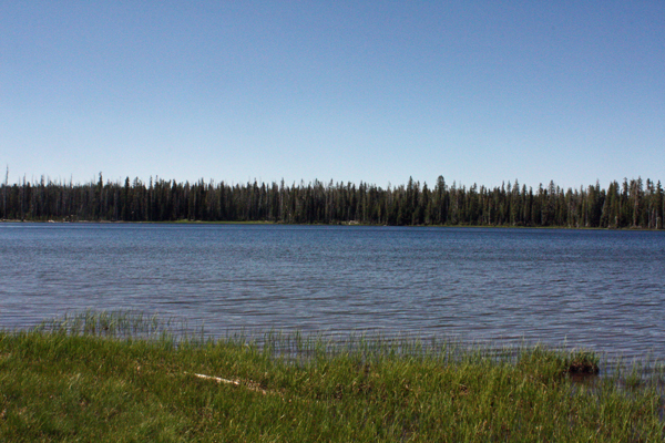
Summit Lake. Photographed July 4, 2012.
After about eight miles, you arrive at Summit Lake. It’s a modest, round lake that sits near the Continental Divide. Some of the shoreline is forested and the trail follows the southern shore. It’s a pleasant spot to stop and eat lunch.
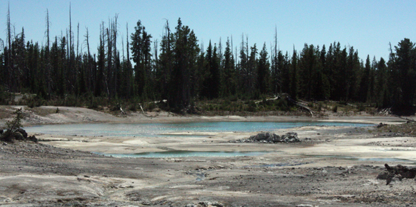
One of the many thermal areas west of Summit Lake. Photographed July 4, 2012.
West of Summit Lake, you can explore a handful of thermal areas. (Use the topo map to get an idea where they are.) Some are close to the trail, while others require more exploration. I always enjoy (carefully!) exploring backcountry thermal areas and these are no exception. You won’t run into an Old Faithful-esque geyser, but there are still plenty of interesting features to see.

A grizzly bear along the Summit Lake Trail about a mile west of Summit Lake. Photographed July 4, 2012.
Notes: There is one campsite at Summit Lake. … Be alert for bears. I saw two grizzlies west of the lake. … Summit Lake is also accessible from the west via a route that cuts across the Madison Plateau. However, the route is longer and finding the trailhead is more complicated. … Plan for mosquitoes at least into July.